I thought it was going to be a satire about what the bastards were going to try next in terms of desecration of sacred sites. Those evil fuckers.
From Vincent Salafia at Save Newgrange:
RTE News - Slane bypass would run close to Newgrange (Video)
The Irish Times - Friday, January 22, 2010
Slane bypass to run close to Boyne heritage sites
THE NATIONAL Roads Authority has confirmed that the proposed route of the bypass of Slane village will pass some 500 metres “from the perimeter” of the buffer zone of the Brú na Bóinne Unesco World Heritage Site.
The road, which will be a dual carriageway, will have “the least impact” taking all factors into consideration, including the archaeology and heritage of the area, a spokesman said.
It will be 3.5 kilometres long and run to the east of the village, which is on the heavily used N2 linking Dublin with Derry and it has been the scene of at least 22 fatal traffic crashes in living memory.
Included in the scheme is a new bridge over the river Boyne which will be about 200 metres long.
The environmental impact statement has been published and submissions on it are being accepted by An Bord Pleanála, which will decide whether to grant permission.
Bypass Slane Campaign group spokeswoman Michelle Power said, “we welcome the plans and look forward to the day permission is granted and funds are allocated for its construction.
“After numerous fatal accidents human life must take precedence,” she added.
Brian Taylor, spokesman for An Taisce in Meath and a resident of Slane said: “I’d be very reluctant about anything that might hold up that road. It has been several years in the offing and it has gone through numerous public presentations and the route chosen appears to be the least offensive [one].”
A spokesman for the NRA said, “we have selected a route with the least impact. It is 1.5 kilometres from the core of the Brú na Bóinne and around that centre core is a buffer zone; this route is 500 metres from the perimeter of that buffer zone.”
However, the statement does say that also within 500 metres of the route are 44 archaeological and cultural sites. The next stage is for An Bord Pleanála to decide whether to hold an oral hearing into any objections or submissions on the proposed route.
Motorway ‘may cost ancient site World Heritage status’
Press Association – 22/01/2010 – 17:55:53
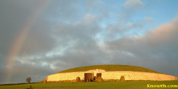
The ancient Bru na Boinne site around Newgrange may lose its World Heritage status if the proposed M2 motorway goes ahead, it was claimed today.
The National Monuments Forum warned if changes are not made to the new motorway plans, the area near the Boyne in Co Meath is likely to lose recognition from the United Nations Educational, Scientific and Cultural Organisation (Unesco).
Dr George Eogan, Professor Emeritus of Archaeology at University College Dublin (UCD), said the new motorway is too close to the monuments and will have a considerable impact on the surrounding landscape.
“Five hundred metres is simply too close, and it is conceivable that Newgrange could lose its World Heritage Status,” he said.
The site can be saved if Environment Minister John Gormley fast-tracks the new National Monuments Bill 2009 according to the National Monuments Forum.
Vincent Salafia, National Monuments Forum spokesman, claimed the minister created unnecessary delays which place Ireland’s heritage at risk.
“We urge Minister Gormley to deliver this long overdue legislation and to ensure it is strong enough to protect Newgrange from this outlandish proposal,” Mr Salafia said.
4 comments:
“…the proposed route of the bypass of Slane village will pass some 500 metres “from the perimeter” of the buffer zone of the Brú na Bóinne Unesco World Heritage Site….”
I think you need to look at this more carefully.
The bypass will actually be over 3km from Newgrange.
The route selection process has been going on for years. The EIS is just the latest step of a very long process. Alternative routes to the West of the village were assessed but any route to the West would be much longer and much more intrusive on the beautiful Boyne valley landscape. Such a road would have to pass over much higher ground and would present an awful scar on the landscape especially as seen by the thousands of tourists who approach Newgrange from the south. The proposed bypass will not be visible from most angles as it will be much lower down.
The existing single lane, 600 year old bridge (http://en.wikipedia.org/wiki/Slane#Slane_Bridge) really should be a protected structure and is in a beautiful location. Instead is a deathtrap as trucks and 1000s of cars cross it every day – 22 people have died so far.
The protected buildings in the village are under threat from the constant rumbling of trucks through the crossroads. There was a multiple car/truck pileup outside the four Georgian houses late last year and it was a miracle that nobody died.
Aside from the obvious safety benefits, Slane itself is a heritage village, and its environment will be improved dramatically by the removal of 1000s of HGVs and cars. See http://www.slanetourism.com/gpage.html for more information on this outstanding example of an 18th century estate village.
An Taisce have commented that the chosen route is the least offensive route. A lot of the recent media attention has focused on Newgrange but as mentioned above, Newgrange will be a considerable distance away from the bypass.
The existing bridge has killed 22 people. Any further time spent revisiting the route will only go back over the exact same issues. The net effect will be to delay the time when people stop being killed. This road is not about economics or shortening journey times by a matter of a few minutes; it is about saving lives. This bypass will reduce the number of deaths and accidents on this notorious stretch of road.
You will find more information here – especially with regard to the precise details of how close the bypass is to Newgrange.
http://www.bypassslane.com/BSCResponse.html
I have read about this distressing issue and have so far been unable to find out if there is any alternative to this route east of Slane . Note that -
'Alternative routes to the West of the village were assessed but any route to the West would be much longer and much more intrusive on the beautiful Boyne valley landscape'.
However cannot find any details of which western routes were considered and why rejected. It would be helpful if details were published on ;-
http://www.bypassslane.com/BSCResponse.html
The western route would travel over the Hill of Slane, and be 50 metres from St. Erc's Hermitage. It would pass 500 metres from Slane Castle.
Quoting from a post on Save Newgrange The Facts:
Knowing the area, as a local, to bring a western bypass,which could be routed between the Hill of Slane and the existing large quarry at Castleparks would mean routing it through the grounds of Slane Castle (50 metres from the front door) and another 50 metres from St. Erc's Hermitage on the opposite side of the road.
To move further west would now bring into the equation the walled demesne of Beauparc House and a deeper river valley which is heavily wooded as it is too steep for agricultural use. A route through here would be in the line of the already mentioned quarry.
Moving a little further west brings the obstacles of the Dollardstown Statue, Dollardstown House, a railway line and bridge, a football field and an even steeper, heavily wooded river valley south of the Boyne.
North of the Boyne we have again the walled estate of Stackallen House and from there to again link up with the N2 you would again be beset with the old cemetery at Gernonstown, difficult geography and topography and b e left with a 12-15 mile by pass through difficult terrain.
To conclude, the proposed route of the bypass is the most viable route and the people of Slane, I have no doubt, will fight to ensure the safety of Newgrange and Bru na Boinne while attaining a safer living environment.
At the end of the day it should be remembered that this road is primarily about safety; not speed, not commuting distances. Just about keeping our children safe.
If the road isn't visible or audible from Newgrange, and is over 3 km away; then you have to ask yourself if this is not a lot of hysteria over nothing. Slane locals are very aware of how privileged we are to live in such an enormously important area. However, we also know that this road does not in any way endanger Newgrange, and it is vital that this very short bypass is provided to prevent deaths in Slane village.
Here's a map of the various routes and important sites:
http://www.facebook.com/photo.php?pid=313641&fbid=153141934718259&op=1&o=global&view=global&subj=286896560291&id=100000673604505
Post a Comment